![](/images/other/stat-length.png)
![Randonnée Marche La Capelle-lès-Boulogne - Sentier des Aulnes - La Capelle-lès-Boulogne - Photo](https://media.geolcdn.com/t/1900/400/ext.pjpeg?maxdim=2&url=https%3A%2F%2Fservices.sitytrail.com%2FGeolivesWS%2FDownloadMedia.ashx%3FTrailID%3D317839%26Media%3D17215_4.jpg)
Sentier des Aulnes - La Capelle-lès-Boulogne
tracegps
Utilisateur
![Longueur](/images/other/stat-length.png)
Longueur
3,3 km
![Altitude max](https://static1.geolcdn.com/siteimages/upload/files/1508320355ic_sort_altitude_max_24dp.png)
Altitude max
103 m
![Dénivelé positif](https://static1.geolcdn.com/siteimages/upload/files/1508320355ic_sort_den_pos_24dp.png)
Dénivelé positif
28 m
![Km-Effort](/images/other/stat-length.png)
Km-Effort
3,7 km
![Altitude min](https://static1.geolcdn.com/siteimages/upload/files/1508320355ic_sort_altitude_min_24dp.png)
Altitude min
89 m
![Dénivelé négatif](https://static1.geolcdn.com/siteimages/upload/files/1508320355ic_sort_den_neg_24dp.png)
Dénivelé négatif
28 m
![Boucle](https://static1.geolcdn.com/siteimages/upload/files/16400158638029165_repeat_loop_refresh_sync_direction_icon.png)
Boucle
Oui
Date de création :
2014-12-10 00:00:00.0
Dernière modification :
2014-12-10 00:00:00.0
![Marche](https://static1.geolcdn.com/sitytour/trail-icons/101.png)
1h00
Difficulté : Facile
![Scannez ce code QR pour ouvrir la randonnée dans l'application SityTrail](https://capi.geolives.com/qq0zvz2zws4bq2lad0pu/sitytour/trails/317839/qr.png?size=200)
Application GPS de randonnée GRATUITE
À propos
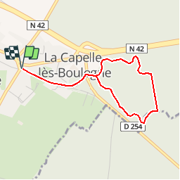
Randonnée Marche de 3,3 km à découvrir à Hauts-de-France, Pas-de-Calais, La Capelle-lès-Boulogne. Cette randonnée est proposée par tracegps.
Description
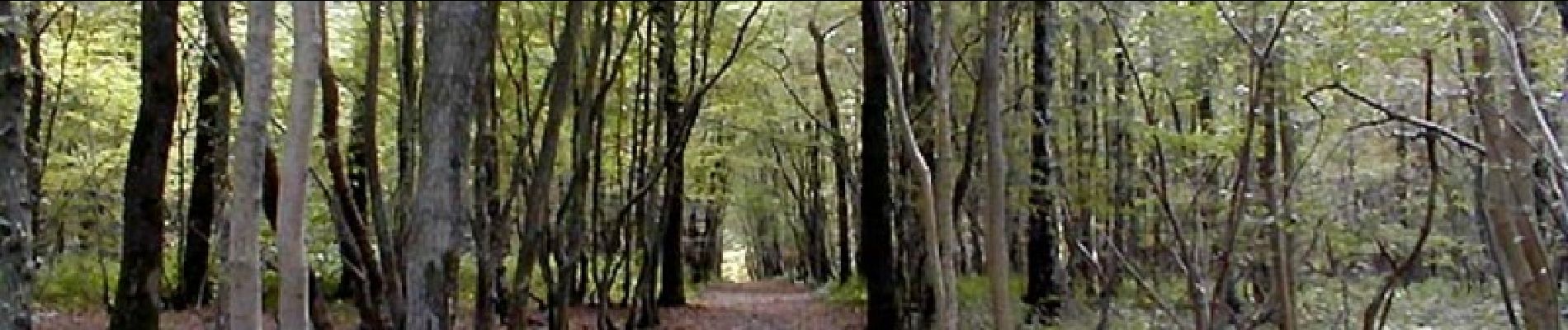
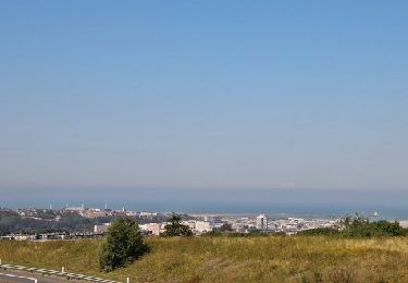
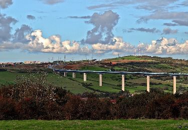
Départ du parking de la mairie. La forêt domaniale de Boulogne-sur-Mer est le principal massif forestier du département. Retrouvez le circuit sur le site l’agglomération du Boulonnais. Crédit photos : Biopale.
Localisation
Pays :
France
Région :
Hauts-de-France
Département/Province :
Pas-de-Calais
Commune :
La Capelle-lès-Boulogne
Localité :
Unknown
Départ:(Dec)
Départ:(UTM)
408835 ; 5620688 (31U) N.
Commentaires
Randonnées à proximité
![Randonnée Marche Saint-Martin-Boulogne - Sentier de la Colonne - Saint Martin Boulogne - Photo](https://media.geolcdn.com/t/375/260/ext.jpg?maxdim=2&url=https%3A%2F%2Fservices.sitytrail.com%2FGeolivesWS%2FDownloadMedia.ashx%3FTrailID%3D317859%26Media%3D17247_5.jpg)
![Marche Marche](https://static1.geolcdn.com/sitytour/trail-icons/101.png)
Sentier de la Colonne - Saint Martin Boulogne
Marche
Facile
Saint-Martin-Boulogne,
Hauts-de-France,
Pas-de-Calais,
France
![](/images/other/stat-length.png)
8,7 km | 10,8 km-effort
2h 0min
![](https://static1.geolcdn.com/siteimages/upload/files/16400158638029165_repeat_loop_refresh_sync_direction_icon.png)
Oui
![Randonnée Marche Baincthun - Sentier de la Pierre de Baincthun - Photo](https://media.geolcdn.com/t/375/260/ext.jpg?maxdim=2&url=https%3A%2F%2Fservices.sitytrail.com%2FGeolivesWS%2FDownloadMedia.ashx%3FTrailID%3D317846%26Media%3D17222_4.jpg)
![Marche Marche](https://static1.geolcdn.com/sitytour/trail-icons/101.png)
Sentier de la Pierre de Baincthun
Marche
Facile
(1)
Baincthun,
Hauts-de-France,
Pas-de-Calais,
France
![](/images/other/stat-length.png)
4 km | 5,2 km-effort
1h 19min
![](https://static1.geolcdn.com/siteimages/upload/files/16400158638029165_repeat_loop_refresh_sync_direction_icon.png)
Oui
![Randonnée A pied Maninghen-Henne - Sentier Le Rendal - Photo](https://media.geolcdn.com/t/375/260/1d61022c-2aaf-46a0-b994-eaf40efecb66.jpeg&format=jpg&maxdim=2)
![A pied A pied](https://static1.geolcdn.com/sitytour/trail-icons/100.png)
Sentier Le Rendal
A pied
Facile
Maninghen-Henne,
Hauts-de-France,
Pas-de-Calais,
France
![](/images/other/stat-length.png)
4,5 km | 5,4 km-effort
1h 13min
![](https://static1.geolcdn.com/siteimages/upload/files/16400158638029165_repeat_loop_refresh_sync_direction_icon.png)
Oui
![Randonnée Marche La Capelle-lès-Boulogne - randonnée Contevilloise - Photo](https://media.geolcdn.com/t/375/260/9b6b9f34-6eca-4d40-b7d7-5ce2ee057578.jpg&format=jpg&maxdim=2)
![Marche Marche](https://static1.geolcdn.com/sitytour/trail-icons/101.png)
randonnée Contevilloise
Marche
Difficile
La Capelle-lès-Boulogne,
Hauts-de-France,
Pas-de-Calais,
France
![](/images/other/stat-length.png)
10,4 km | 12,3 km-effort
8h 23min
![](https://static1.geolcdn.com/siteimages/upload/files/16400158638029165_repeat_loop_refresh_sync_direction_icon.png)
Oui
![Randonnée Marche La Capelle-lès-Boulogne - randonnée Capelloise - Photo](https://media.geolcdn.com/t/375/260/a3b0a2cd-1248-41ed-9bf0-ed79ba598804.jpg&format=jpg&maxdim=2)
![Marche Marche](https://static1.geolcdn.com/sitytour/trail-icons/101.png)
randonnée Capelloise
Marche
Facile
La Capelle-lès-Boulogne,
Hauts-de-France,
Pas-de-Calais,
France
![](/images/other/stat-length.png)
6,2 km | 7 km-effort
2h 26min
![](https://static1.geolcdn.com/siteimages/upload/files/16400158638029165_repeat_loop_refresh_sync_direction_icon.png)
Oui
![Randonnée Marche Saint-Martin-Boulogne - randonnée blanc pignon Mont Lambert - Photo](https://media.geolcdn.com/t/375/260/f6e47299-c7fb-49bc-9b45-2b4d89c59833.jpg&format=jpg&maxdim=2)
![Marche Marche](https://static1.geolcdn.com/sitytour/trail-icons/101.png)
randonnée blanc pignon Mont Lambert
Marche
Moyen
Saint-Martin-Boulogne,
Hauts-de-France,
Pas-de-Calais,
France
![](/images/other/stat-length.png)
28 km | 37 km-effort
2h 25min
![](https://static1.geolcdn.com/siteimages/upload/files/16400158638029165_repeat_loop_refresh_sync_direction_icon.png)
Non
![Randonnée Marche Conteville-lès-Boulogne - La Fontaine aux Charmes - Conteville-lès-Boulogne - Photo](https://media.geolcdn.com/t/375/260/ext.jpg?maxdim=2&url=https%3A%2F%2Fservices.sitytrail.com%2FGeolivesWS%2FDownloadMedia.ashx%3FTrailID%3D112084%26Media%3D9812_2.jpg)
![Marche Marche](https://static1.geolcdn.com/sitytour/trail-icons/101.png)
La Fontaine aux Charmes - Conteville-lès-Boulogne
Marche
Facile
(1)
Conteville-lès-Boulogne,
Hauts-de-France,
Pas-de-Calais,
France
![](/images/other/stat-length.png)
5,8 km | 6,9 km-effort
1h 30min
![](https://static1.geolcdn.com/siteimages/upload/files/16400158638029165_repeat_loop_refresh_sync_direction_icon.png)
Oui
![Randonnée sport Baincthun - Sentier de la Marguerite - Photo](https://media.geolcdn.com/t/375/260/ext.jpg?maxdim=2&url=https%3A%2F%2Fsecurestorage.geolives.com%2Fsitytour%2Ftrail-bg%2Fdefault.jpg)
Sentier de la Marguerite
sport
Très facile
(1)
Baincthun,
Hauts-de-France,
Pas-de-Calais,
France
![](/images/other/stat-length.png)
14 km | 18,2 km-effort
Inconnu
![](https://static1.geolcdn.com/siteimages/upload/files/16400158638029165_repeat_loop_refresh_sync_direction_icon.png)
Oui
![Randonnée Marche Conteville-lès-Boulogne - La Fontaine aux Charmes - Photo](https://media.geolcdn.com/t/375/260/ext.jpg?maxdim=2&url=https%3A%2F%2Fstatic1.geolcdn.com%2Fsiteimages%2Fupload%2Ffiles%2F1553511878bg_sport_marche.png)
![Marche Marche](https://static1.geolcdn.com/sitytour/trail-icons/101.png)
La Fontaine aux Charmes
Marche
Moyen
Conteville-lès-Boulogne,
Hauts-de-France,
Pas-de-Calais,
France
![](/images/other/stat-length.png)
6 km | 7,2 km-effort
1h 37min
![](https://static1.geolcdn.com/siteimages/upload/files/16400158638029165_repeat_loop_refresh_sync_direction_icon.png)
Oui